

Capitol Reef National Park is nestled comfortably in the Middle of Nowhere, south central Utah. For hikers and campers seeking a true desert experience, this location couldn’t be more perfect. As with all the National Parks, there are crowds to deal with, but it’s a far cry from the hordes at Zion or Arches. At first glance on the map, it’s hard to imagine that the Reef offers much in the way of exploration; its long, narrow profile looks daunting to those hoping not to drive far.
But just off the main drag, Highway 24, there is a myriad of easy to strenuous options for exploring. During my first day in the park, I opted for the long slickrock trail that leads to the Navajo Knobs, a destination that would reveal both solitude and breathtaking views.
The route begins at the Hickman Bridge trailhead, just a short drive east of the visitor center. On the way you can stop at a small pull off and glance at some petroglyphs left behind on the walls by the first people to enjoy the scenery here. Gear up and take off down the trail that skirts the Fremont River; in early June the river was running high and swift. Soon you begin the ascent, and it won’t stop for the next 2-3 hours.
After warming up your legs on the initial switchbacks, the trail splits and offers hikers the chance to get up close and personal with Hickman Natural Bridge and a small ruin. Choosing to see this portion will add about 2 miles to the hike. Continue past the fork to the Navajo Knobs Trail and feel the burn.
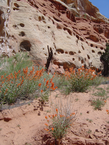
The trail is like many in this part of the desert; burning slickrock of bright red and pale orange marked by rock cairns. The real treat is in the diversity of rock and flora. Black volcanic boulders of all shapes and sizes dot the sides of the trail and hills, while a dazzling display of blooming cacti and other native plants provide eye candy on your stroll. Who says there is no color here? Magenta cactus blooms, bright red penstimon and Indian paintbrush, and yellows of every shade betray the barren nature of the rock landscape. Hit this park in the bloom season and you will become a believer in the beauty of the desert.

The trail keeps climbing over the slickrock, twisting around the sheer walls that tower overhead. Occasional shade, if even for a few feet, provide much needed relief from the sun. Climb through football sized fields of smooth, sloping rock and eventually (21/4 miles, to be exact) you will reach the Rim Overlook. Some 500 feet straight down is the historic town of Fruita. You get a bird’s eye view of the lush green orchards that early pioneers cultivated. The visitor center and adjacent campgrounds can also be seen. Outstanding views to the south reveal bits and pieces of the Waterpocket Fold that stretches all the way to Escalante; truly a view worth the sweat. Fuel up with some water and a snack because you are only halfway there… the Navajo Knobs await!

The trail takes on a new character shortly after the overlook; instead of continuous climbing, you now begin to slowly descend and wrap around the walls, only to begin another ascent on the far side of the many small pour off canyons that the trail crosses. Again, cairns mark the way and the slickrock is only occasionally broken by short sandy sections. If you’re careful in choosing your path you might not leave a single footprint for other hikers to find. Pay close attention to the details of the hike; in addition to the volcanic rock and flower displays there are also many tiny arches and wind-carved Moki Steps to gawk at on the walls.
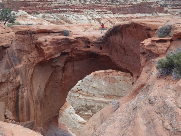
When you are almost to the Knobs, a rock formation called The Castle comes into view below you. The Castle is composed of eroding spires and turrets perched atop a crumbling red rock base; no telling how long this castle will be towering over the desert. Wind though one more series of up and down, and you will see the destination to your right: a collection of whitish-yellow rock outcroppings that justify their name.
The Knobs, like most of the rock pillars in this land, are falling down… slowly becoming victims of the power of wind and water. The last boulder strewn 100 feet are a testament to this fact. Climb up the final unmarked portion of trail and raise your arms atop the cluster- you made it! The Navajo Knobs are not a peak or summit by any stretch, but it’s hard not to feel like you’re on top of the world here (well, the top of the Reef, anyway). Take in the impressive 360 degree view of the park and surrounding areas. If you have a map handy, you can easily spot many of the major landmarks of the area. The Henry Mountains tower to the southeast; Fishlake National Forest to the west and Dixie NF to the southwest show off their snow covered upper reaches, and the Waterpocket Fold stretches almost endlessly to the south. Linger as long as you like; you probably won’t see anyone else for quite a while. As any savvy hiker knows, the longer the trail, the smaller the crowd, and this is one view you will want to enjoy.

The hike is an out and back, so simply retrace your steps 4 1/2 miles to the trailhead. Take a look for sites you might have missed on your way in. By the time you return to the trailhead you will be covered in sweat and looking for relief: the Fremont River is ready to heal your wounds. Wade into the river and dunk your head; a careful observation of the water will reveal some of the healthy trout that call it home. The Navajo Knobs Trail is just one of many options for a long day hike in the Reef, but as far as diversity of terrain and terrific views go, it’s hard to beat.


1 thought on “Surfing the Reef Part I: Navajo Knobs Trail”