

Glen Canyon National Recreation Area is a vast region within the Colorado Plateau that contains some of the best canyon country in the world. It’s quite a haul to get there from northern Utah, but well worth the trip. Hikers and backpackers flock to the region in springtime but there’s so much ground to cover that it never gets too crowded. There is literally a lifetime worth of exploring available in the area, so start your tick list with two classics: Neon and Ringtail Canyons. The attraction here? The Escalante River, the Golden Cathedral and one of the darkest little slot canyons around.

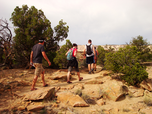
First things first- getting there. Make the long drive to the town of Escalante and stop in at the visitor center (755 West Main Street). Backpackers need to pick up a free overnight permit from the ranger desk. The rangers are the best resource for advice on water sources, river flow and trail tips. From town, head east on Utah Scenic Route 12 to Hole-in-the-Rock Road. Head down the graded/washboard road 17.2 miles and turn left at the signed road for the Egypt Trailhead. The Egypt road is maintained but rough. Most vehicles can make it in good conditions with some careful driving. Keep right at the only fork and 9.5 miles later you will arrive at the Egypt Trailhead. Chances are you’ll see plenty of other cars parked here; this might be the most popular trailhead in the area. Throw your pack on and get ready for the adventure!
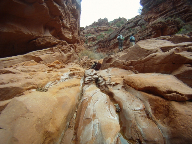
Hikers immediately put their knees to the test by plunging down the Egypt bench. A slickrock descent of a few hundred feet will get you to the badlands below the parking area. The trail is marked with cairns (small piles of stacked rocks) and the slickrock is worn enough to see a faint trail. There are also plenty of scuff marks from horseshoes; local guides use the beasts to carry their heavy loads down to the Escalante River. Within the first mile you will see a marker letting you know you are entering GCNRA. The trail will change to a mix of rock and deep sand; tough going to be sure. Trend northeast towards Fence Canyon as this is the most scenic way to get to the river. Avoid entering the south fork of Fence Canyon or you will be stopped at an impassible dry fall. Instead, aim for the area between the north and south forks (easily identifiable on the “Egypt” topographical map that you should have with you). The trail is faint at the top of the canyon, but the cairns and foot path will become easy to follow once you begin your descent. Switchback your way to the bottom of Fence and get ready to enter a different world.

Fence Canyon has plenty of water. A small creek and lots of pools are the reason for the canyon’s riparian nature. Huge cottonwood trees, bushes and grasses abound on the floor. It is 3.5 miles from the trailhead to the bottom of Fence. The trail will lead you to the Escalante River. This little river is the life source for the entire region; all the surrounding canyons drain into it as it makes its way to Lake Powell. Slip on your water shoes or old sneakers and get wet- you’ll be crossing the Escalante plenty on this tour. Hike downstream for approximately 20 minutes to reach the mouth of Neon Canyon.
Neon meets the river on the east side. Before entering the canyon search the walls to the north and south for faint petroglyph panels. It’s only 1/2 mile until you reach the Golden Cathedral, but the gorgeous canyon may distract you. Walls of deep red and orange seem to glow in the proper light, and that’s how Neon got its name. The canyon has many healthy cottonwood trees and numerous pools of cold, clear water. Scramble around the boulders and soon you will be ready to worship: the Golden Cathedral marks the end of the hike. This amazing feature is a double natural bridge that was once two potholes. Thanks to years of erosion the bottoms dropped out and created the Cathedral. Take your time time to enjoy this landmark, if you’re lucky you may even get to watch a technical canyoneer rappel through one of the holes! Double back the way you came and head downstream again- it’s time to see Ringtail.

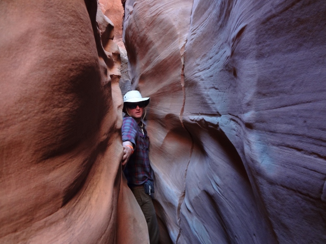
Another 20 minutes downstream a small wash enters the river on the east side. Make your way through the thick brush and scramble up the rocks to the mouth of Ringtail Canyon. This slot may be the darkest in the entire area! As soon as you enter, the temperature drops and the sun all but disappears. Light is so scarce that you may want to have your headlamp ready. The walls of Ringtail are narrow; you’ll definitely be turning sideways to make it through a few spots. Explore up canyon as far as your skills will allow, my partners and I only made it about 1/4 mile before we were turned around by a tough section. Ringtail is short, spooky and pretty damn amazing. Return the way you came and make your way back up the river, up Fence and back to your car.

You can do this trip in one long day, but what’s the rush? There are plenty of good camping spots in Fence Canyon and along the Escalante River. Avoid camping in Neon Canyon as this can ruin the experience for other hikers. Whether you take your time or opt for a day hike one thing is certain: Neon and Ringtail are a great way to begin your exploration of Glen Canyon National Recreation Area.
Author’s Note: In early spring the Escalante River is quite cold and swift. Late spring/early summer is a better time to explore if you have children or novice hikers in your group. Know the weather forecast as these canyons are prone to flash flooding. No fires are allowed in GCNRA so bring your camping stove and always practice Leave No Trace ethics.


1 thought on “Hiking the Escalante River to Neon and Ringtail Canyons”