
No canyon in Zion National Park is as revered by hikers and photographers quite like The Subway. This natural drain-pipe earns its title from the perfectly carved, rounded tunnel that causes shutterbugs to shudder, and canyoneers to explore these twisting, out-of-this-world waterways with zeal.

The Subway is actually the Left Fork of North Creek Canyon, and the actual “subway” section is just a small part of the hike. But boy what an awesome section that is. According to park officials, The Subway is the second most popular hike in Zion, and as such, they strictly regulate the amount of people that can go in per day. This quota system requires hikers to reserve and pay for permits. Despite the hoops you have to jump through, the intense beauty of this hike is more than worth it, and should not be missed.
Do not be fooled by The Subway’s popularity, however, as the hike is not easy, and along with technical canyoneering skills, you’ll also require savvy route finding skills. It’s very easy to get lost looking for the way into the canyon, and many people have missed the exit out, leading to hours and miles of retracing steps, or getting lost entirely and needing rescue.
If it’s your first time in The Subway, you should bring a map, and/or guidebook, or take someone along who’s been there before. To start, take two vehicles and drive up the Kolob Reservoir Road through the town of Virgin into Zion National Park. Leave one car at the Left Fork trailhead approximately eight miles from Virgin. This is the end of the hike. Continue to drive up and pull into the Wildcat trailhead where the hike begins.

The trail is highly used and well maintained as it travels across a beautiful area of pines and meadows. Signs lead the way to the descent into the canyon, but if you have any further doubts about what fork to take, follow the advice a Zion ranger gave me – if it doesn’t look like a trail thousands of people use, then you’re on the wrong trail. Russell Gulch is the feature that the main trail descends into. A huge slickrock section leads down into the canyon, and the route is marked by cairns.
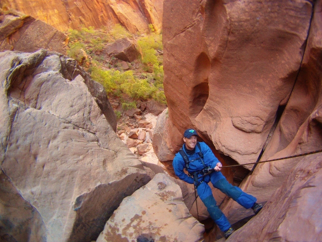
At the bottom of the gulch, cairns lead the way to a saddle where you then descend into Left Fork Canyon. Once there, a steep trail leads down to what is referred to as “the first obstacle.” We chose to rappel the whole thing, but it is possible to down-climb it according to guidebooks. When our group made the descent, there were slings already there to use as anchors. But don’t ever expect anchors to magically appear when you need them, so you should always bring your own, just in case.

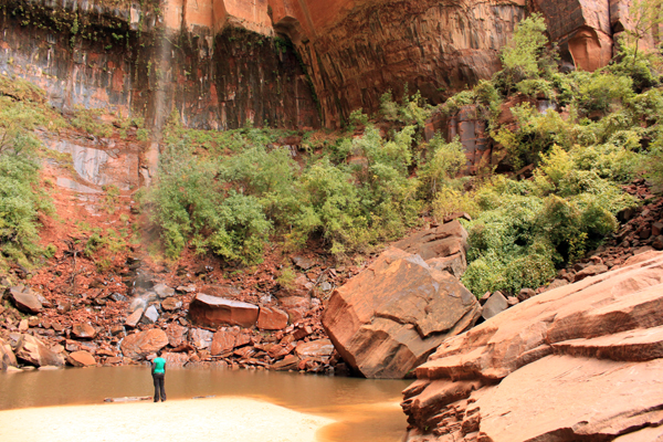
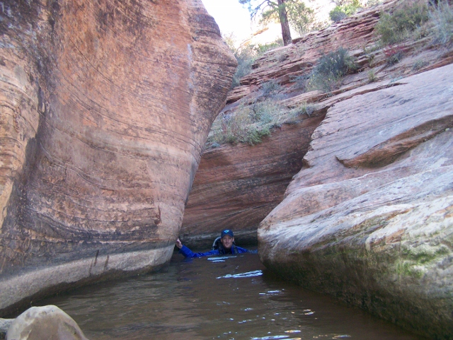
Once in the canyon bottom, the real fun begins. The hike starts as a leisurely walk through the river amid red rock canyons carved like sculptures. The occasional swim through tight sections and large pools keep things interesting, and despite some scrambling and rock hopping, nothing technical is encountered… yet.
After about a mile, it’s time to break out the rope. Keyhole Falls is the start of the technical canyoneering section of The Subway, and caution must be used. Use your rope as a handline to get through these short but dangerous descents, or for more safety, set up a rappel with the bolts on the north wall of the canyon.

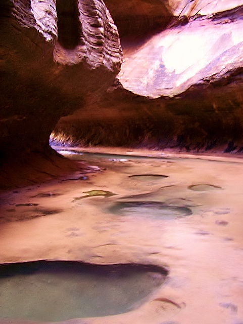
Beyond Keyhole Falls, take in the otherworldy beauty of The Subway. The curved rock around you is like a giant drainage system for desert water that unleashes the imagination. If you time your day right, sunlight angling into the enclosed spaces increases the dramatic scenery. It’s not uncommon to run into a flock of photographers taking pictures in the main Subway section. Slow down, enjoy the pools, explore the nooks and crannies, and soak it all in. After all, discovering The Subway is the reason you made the journey, so make the moment last.

A bit further down canyon, another rappel from chain anchors gets you down a small, sloping cliff. From here, go back upstream to a waterfall that hides a secret room. Deep pools here just beg to be jumped into – the watercourse is a natural playground. When you’ve had your fill, continue downstream and enter the part of the canyon that earns the moniker, “The Subway.” Hike through and look back at the perfectly round canyon. It’s one of the most photographed and amazing scenes in Utah. Appreciate it, then continue on (or else the photographers will get angry with you standing in their shot.)

The rest of the canyon is a long, but fun romp through boulder fields and forests with several stream crossings. While an actual trail can be followed, we found hiking the stream bottom was easier than the up-and-down meanderings of the footpath. As you hike, keep your eyes peeled for large, grey slabs of rock that look like dried mud on the right. There are dozens of fossilized dinosaur tracks embedded in the stone.
The next course of action in finding the exit out of the canyon.The path is well marked and cairns help lead the way through any questionable areas, but vigilance is needed or else you can walk right by the exit without knowing it. To know you’re getting close, you cross two streams that cascade down from the right before the exit trail is reached. Also, keep looking up for the tell tale “lava flow” on the upper part of the canyon wall. This jumble of dark, red rocks is an indicator of where the trail begins.

Signs marked “Left Fork Trailhead” are planted at the start of the exit trail. The path steeply ascends a cut in the cliffs to the top of the “lava flow.” At the top, continue on the mesa top through juniper and pine forests to the trailhead where you left the shuttle vehicle.
To get a sense of hiking in The Subway, check out the video we shot while there. The Subway section begins at 2:06.
Details: The Subway may seem easy at a glance, but unless it’s a very hot day, mandatory swims mean wetsuits or drysuits are usually required to prevent hypothermia. Also, flash floods are always a risk, especially if rain is forecast. Always check conditions with park rangers before heading into the canyon.
Knowing how to rappel is mandatory. Along with drysuits and warm clothes, bring a rope, harness, and slings or daisy chains to anchor yourself to the rock. Know how to properly use your gear. Helmets are also a good idea.
To explore The Subway, you’ll need a permit. Get one from the Zion National Park Visitor Center where they are available the day before you plan on canyoneering. Permits can also be reserved up to two months in advance on their Backcountry Reservation System.
To get to The Subway, drive Highway 9 to the town of Virgin. Turn north on the Kolob Reservoir Road into the Kolob Canyon area of Zion National Park. Park one car at the Left Fork trailhead approximately 8 miles from Virgin. Continue to drive up and pull into the Wildcat trailhead where the hike begins. Continue as described above.
For more comprehensive information about canyoneering The Subway and any other Zion National Park slot, we highly recommend buying a copy of the book, “Zion: Canyoneering” by Tom Jones.


1 thought on “Canyoneering The Subway in Zion National Park”