Climbing the highest peak in a state – it’s a magnetic cause for us hikers who desire peak-bagging in all its forms, so Wheeler Peak, located in Nevada near the Utah border, was on my tick list for a long time. *cue record scratch* Well, turns out it’s, ahem, not the highest peak in Nevada, which I discovered upon arrival (didn’t do my homework on that one.) The highest Nevada mountain is Boundary Peak. But at 13,063 feet, Wheeler peak is just 81 feet below Nevada’s highest point, putting this mountain in 2nd place – still a very worthy summit to stand upon.

Wheeler Peak is located in Great Basin National Park, which encompasses a massive mountain range that looms over the sagebrush flats of western Utah and eastern Nevada. Great Basin is most well known for the ancient, 5,000-year-old Bristlecone Pines and tours of the Lehman Caves. But high above all that, towering above all other summits in the Snake Range, stands Wheeler Peak.
If you want to summit Wheeler Peak, you’ll need to get an early start, especially if climbing in monsoon season, to avoid thunderstorms. To do that, it’s best to camp in Great Basin where several developed campgrounds are there stake your tent and get some sleep. On summit day, drive up the Wheeler Peak Scenic Drive as it climbs from sage and grass topography, to a dramatic shift through aspens and fragrant pine forests at the highest elevation. Once there, you’ll feel like you’re floating on a sky island as the desert spreads out far below in all directions.

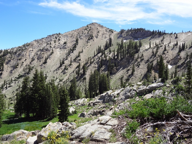
After parking at the Summit Trailhead, the route is very straightforward as it winds through stands of aspen and across meadows to Stella Lake which shimmers beneath Wheeler Peak like a jewel. Continuing on, the trail joins up with the Alpine Lakes Trail junction where a short left jog joins up with The Wheeler Peak Trail on the right. There are well marked signs at each junction, so no chance of getting lost here.
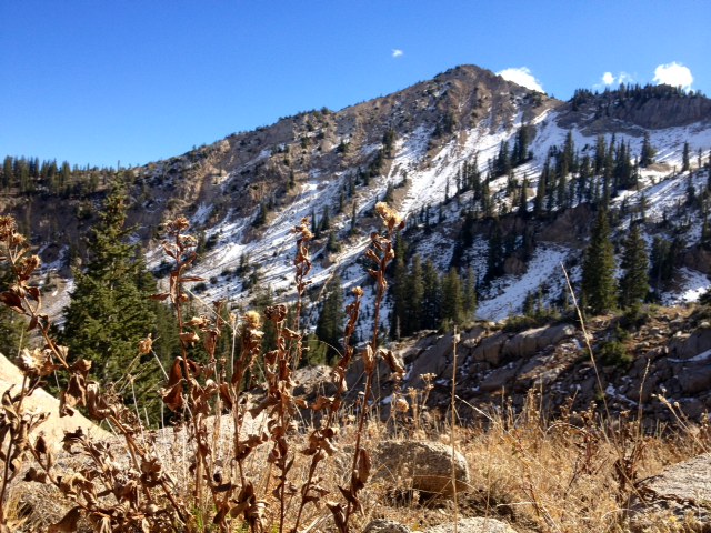
After the turn onto Wheeler Peak Trail, the route starts to climb up the slopes of Bald Mountain. As you gain elevation, the views get more and more dramatic. The vegetation begins to thin and before you know it, you’re in the high alpine zone above tree line. From here, the trail becomes a boulder field that traverses the ridge where hikers can now see the western side of the range, and vast tracts of land that stretch for miles into Nevada. Although the terrain is nothing but rocks from this point on, the trail is still very visible as thousands of footsteps from previous hikers has leveled the stones and ground into a sort of loose walkway.

After the shoulder traverse, things start to get steep. The trail goes straight up the ridge through a series of switchbacks. This is the final push to the summit, and for tired hikers not used to the high altitude air, it seems to go on forever. But what the hike looses in pure cardio torture, it more than makes up for with views so vast and distant, that you can’t take it all in during one sitting. In fact, it’s difficult to reach the summit not from exertion, but from stopping every 100 feet for pictures or just taking a break to soak in the scenery.

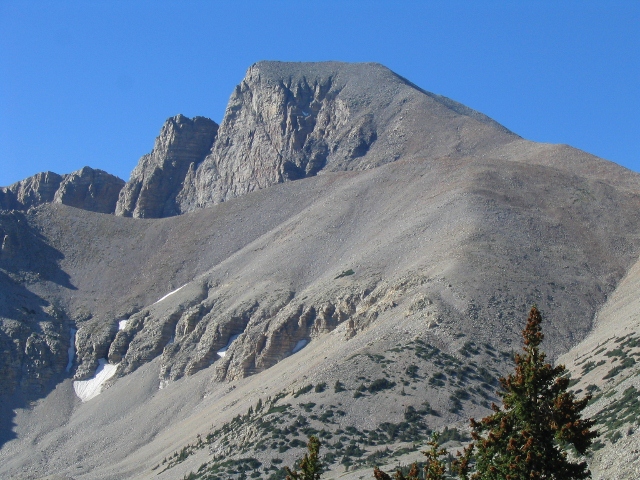
After dogged determination, the summit will finally be achieved. Due to its prominence in this small mountain range, Wheeler Peak offers a 360-degree, unobstructed view that is among the best anywhere. in addition, sheer cliff drops on three sides draw hikers to the edge for group photos and a quick peek into the abyss. Hopefully you saved your lunch for the top as it’s the best place to have a picnic. The summit is large and level, with dozens of flat rocks and depressions where you can settle in for a snack or a nap. There’s also a rudimentary rock shelter where you can hide from the wind if need be. The shelter also houses the summit register if you’re into leaving your “Kilroy Was Here.”

After exploring the summit and taking myriad photos, you can descend back the way you came, or return to the bottom via the summit trail, which intersects with the Alpine Lakes Loop Trail. From here you can see the mountain lakes and return to the car, or continue on down the Bristlecone-Glacier Trail where seeing the oldest living beings on Earth is a must-do.

The hike up Wheeler Peak is 8.6 miles round trip with an elevation gain of 2,900 feet to the 13,063-foot summit. It’s a moderately easy hike with no technical areas, just steep, rocky sections to navigate. For anyone looking to stand atop a remote mountain summit near Utah, then Wheeler Peak is worth putting on your own tick list, whether it’s the highest peak in Nevada or not.