

Kings Peak is the tallest mountain in Utah, so climbing to the summit is a rite of passage for any hiker living in the state. All serious hikers around the country have one thing in common: an insatiable desire to climb the highest peak in the state they live in. Standing atop the king of mountains within invisible state lines is a ritual among the outdoorsy, and this fact is as true in Utah as anywhere else. This means Kings Peak is one hell of a popular mountain to climb.

Everyone knows that Kings Peak is the tallest mountain in the Beehive State, topping out at 13,528 feet. As such, every summer season sees hundred of people attempting to top out on the peak. Located in the Uinta Mountains of eastern Utah, King’s Peak has always been a favorite of serious hikers, casual backpackers and Boy Scouts looking to test their mettle against the elements.
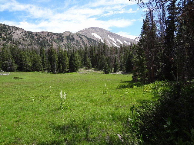
The usual way to climb Kings Peak is to do it in three days as it is a 29 mile round trip hike from the Henrys Fork trailhead. The first day consists of an easy, relatively flat 8.3 mile hike to Dollar Lake where there are several awesome places to set up camp. Along the way, the trail winds through pine forests along the Henrys Fork River until it rises up into the open meadows surrounded by the jagged mountain tops of the Uintas.

Once at the lake, there is good fishing at Dollar Lake and time to relax in the alpine air while watching the moose do what moose do. Camping is plentiful around Dollar Lake. The only decision to make is whether to camp near the lake for a nearby water source, or away from it so you can have a campfire. Decisions, decisions.

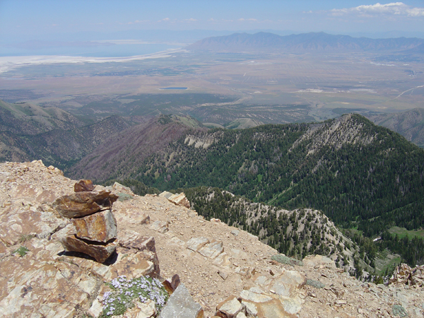
The second day of the trip is summit day. Just over six miles of trail gets hikers to the top, but all of it is steep with some scrambling to get to the summit. The route is well marked with cairns, although the trail is obvious. The scenery along the way is hard to beat as Henrys Fork, Painter Basin, Gilbert Peak, and Kings Peak create an endless array of some of the most picturesque mountain country in the nation.

After reaching the top, pictures and celebrations precede a well deserved break before gathering up the motivation to begin the descent. Six miles of steep downhill lead back to camp for a total of 12.2 miles for the day.
Of course, the third day is all about packing up and heading back down to the car. After two days of non-stop hiking, hefting a pack filled with camping gear is a burden fit for ending a sweet trip in the Uinta Mountains. Following the footsteps laid down two days before leads back to the car for a total of 28.8 miles round trip.

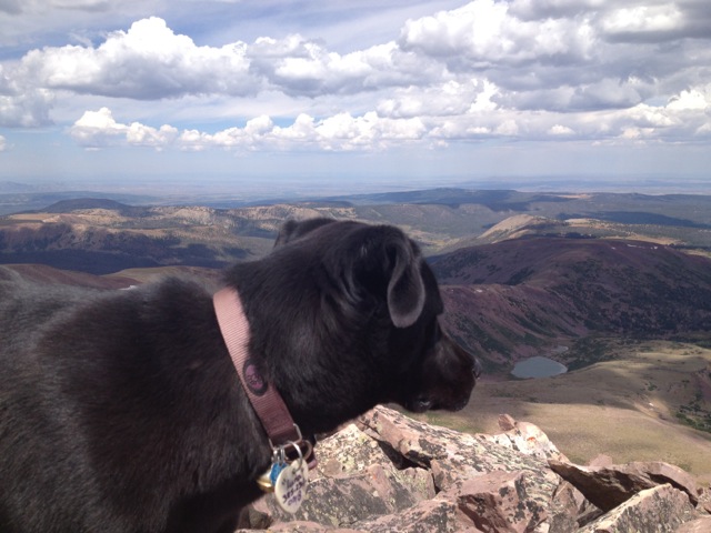
Even if Kings Peak wasn’t the tallest mountain in Utah, swarming with people climbing there simply to “bag the peak,” it would be an incredible hike anyway. The mountain environment, enfolded in crags of granite, peppered with pines and wildflowers, would still place it at the top of Utah’s best hikes. It’s also a great hike for dogs who are in shape, and are large enough to travel over scree and boulders.

To get to the Henrys Fork trailhead, drive Interstate 80 through Wyoming to State Route 414. Drive south to Mountain View and continue through town until the road becomes Route 410 until it reaches the town of Robertson. Turn west on Uinta County Road 283 toward Bridger Lake until it comes to Forest Road 017. Turn left and drive to Forest Road 077. Heading south from here leads to a fork where a right turn will take you to the Henrys Fork Trailhead. Or use a Google map and GPS because it is a little confusing to find the way there.

Hello,
This looks like a fun hike! I was wondering if hikers can legally carry fire arms with a concealed permit to these hikes. Any information on this would be great. Also what is legal up in that hike? Do you need a license to fish up there? Basically what can you and cant you do during the hike? Me and some of my buddies wanted to do like a survival trip kind of event where we can fish, set traps for small rodents and drink out of natural water sources and anything else a survival trip would be. We want to be sure of the rules and dont want to break any laws. Also if you know of any other cool locations for this kind of activity let me know.
Thanks for your time.
Daniel,
In the State of Utah, as long as you have a concealed firearms permit, you can legally carry a gun pretty much anywhere. If I were you, I’d check with the local authorities first about the rules before heading out, just to be safe. As for fishing, you will need a license to fish in the Uintas. There is a forest ranger that hangs around the camping areas near King’s Peak, so be on your best behavior.
My dog is 6 months old (46 lbs.); a lab/bordercollie mix and I’d like to take him up to King’s Peak. Just wondering about the bouldering at the end, whether or not he can make it up. He can scramble over decent sized stuff, but if it’s rock climbing, where I have to use my hands and pull myself up rocks that are 4-8 feet, he doesn’t have the advantage of hands. He also doesn’t know to to go down backwards– it’s all face first for him. Bad on real steep stuff. I’ve had to carry him down a big rock or two. What is the terrain at the end like? I’ve seen a pic of a big rock field that looks like no problem for him, but don’t know if that’s the worst of it. SCT
A lab mix should make it fine, as there is no rock-climbing type scrambling at the top per se. However, the rock hopping can be a bit tricky, and one dog that was in our group actually fell off a large rock on the way down after freaking out a bit. She landed on her back but was just fine, only a bit dazed. So you may find some sections where your dog will need a boost or help down… might want to have him wear a harness you can grab and lift.
Not all dogs can make it though. Another time I ran into a couple who turned around because their dog could not negotiate the terrain. It’s really whether or not you think your dog can handle it.
Good luck!
Dear Mr. Hargrave,
I am planning to summit Kings Peak during the second week of August, 2013. Could you please supply a bit of information.
Initially, what is the weather regularly encountered in this area at this time of the year. I am making this trip late in the summer to avoid the thunderstorms encountered in the higher elevations of the western mountains during late spring to mid-summer.
Secondly, what should I expect in regard to the presence of large carnivores, particularly bears and mountain lions, near the trail. I will not be packing a firearm but plan to make enough noise on the trail to keep from suprising the big critters.
Finally, are there other camping areas along the trail besides those at Dollar Lake? I should like to break the summit trail into three parts or days rather than two as you have described. I will need time to aclimate and three days, as was my program on the Mt. Whitney climb, seems to be the best for me.
Please get back to me when you can.
Patrick
Patrick,
August is the ideal time to climb King’s Peak because, you’re right, there is less chance of afternoon thunderstorms, but that doesn’t mean zero chance. I got caught in a massive lightning storm on the way down one year, so it’s still good practice to be off the summit by noon.
There are bears in the area as well as moose. Use good judgement and hang your food and toothpaste etc in a bag from a tree far away from your campsite. But honestly, I wouldn’t worry much about encountering anything in broad daylight, and the moose seem fairly tame if you stay well away.
As for camping, you can camp wherever you want. Just find a flat spot, and there you go. Dollar Lake is the usual spot because it’s a water course and you can go fishing. If you want to split it into several days, Alligator Lake is another good spot to camp. It’s about 2.6 miles from the Henry’s Fork trailhead.
Hope all this helps and good luck.
Jared,
Thanks for your reply. The information is most helpful. I will drop you a line in September to let you know how things went. I am planning to do Boundry Peak in Nevada and Borah Peak in Idaho on a circuit starting from Seattle. This will make 44 state highpoints to date.
Again, thanks for the information.
Patrick
Jared,
Great info on hiking King’s Peak and excellent pictures. Can I ask what month it was when you get these shots? I’m planning an trip sometime this summer and would prefer to go as early as possible to avoid the crowds and your pictures look like the perfect time of year to go with still a little bit of snow on the mountains but none down in the basin. I don’t mind the cold and ice, I just don’t want to be marching through slush.
Thanks,
Joseph
Hey Joseph,
These pictures were actually taken in late summer/early fall. September… ish. There was some autumn snow up high already when we did the trip.
Hi Jared,
About how many people typically hike Kings Peak for the July 4th weekend?
What are the levels of mosquitoes and horse flies(or other biting insects) typically on the July 4th weekend?
What is the snow pack typically for the July 4th weekend? What about this year?
John
Hi John.
I don’t know how many people hike King’s Peak on 4th of July weekend. Never been up there at that time of year. As for biting bugs, they’re really, really bad until fall.
Snowpack-wise, I’d expect some lingering snow, but not enough to keep anyone from climbing the peak, especially this year.
Hope this helps and good luck!
YO Jared … thanks for sharing your experiences in climbing King’s Peak. I am planning a road-trip that will include crossing the Grand Canyon (North to South Rim, then return the next day), hiking and exploring Utah’s National Parks – then a one-day hike / climb of King’s Peak. Part of the challenge is optimizing on the weather / trail conditions. I’ve been in the Canyon in early June – and although it gets hot, it is certainly more bearable than July. My current thought is to hike Kings’s Peak June 14 or 15, 2014. Could you tell me what I can expect in terms of the trail composition? Lots of snow / mud / ice? What might I expect in context of the last six miles hiking? Are there any other tips with respect to folks that plan to hike the entire trip in one day? Thanks for your thoughts. PDG2
June is definitely a little early for climbing King’s Peak. Depending on what kind of spring we’ll have, there will be a lot of snow on the summit. The trail will also be muddy below in the meadows. I’d expect the first third of the hike to be dry as it is very rocky. If you’re prepared for the snow, and can get off the summit before the snow gets too soft and you’re post-holing the entire way, you should be good to go. Of course we could have a hot spring and it all melts by then… who knows? Good luck!
Kings is an amazing area, definitely worth the trip! I’ve done it twice, once with a group where we took 4 days (one extra day just to enjoy the Henry’s Fork Basin and fish in the lakes and streams), and a second time with our high school cross country team, when we did the up and back in one day (mix of running and walking) while camping at nearby Marsh Lake. Long day, amazing memories, and beautiful scenery. Careful of the moose though, as some of our teammates were running along the trail and startled a mama and her calf.
I know this is a bit late and most of your readers seem to be seasoned hikers,but almost all of the lakes and streams in UT have giardia. Make sure you have a good water filtration system
I’m wondering about how late is too late to do King’s Peak. When do they close access to Henry’s Fork trailhead, etc.? I’m thinking of no later than mid-October – UEA weekend. What are the likely conditions . . .
Hi Clayton. Kings is doable depending on conditions in mid October. Expect snow and really cold overnight temperatures. Be prepared for winter-like conditions.
They don’t close the road on a certain date (as far as I know.) They close it once it becomes too dangerous for vehicles due to snow. Usually sometime in October or early November. You’ll be rolling the dice either way if you’re planning a mid-October trip.
We’re debating renting goats when we climb Kings next summer. Any thoughts on whether that would be helpful for hauling gear, or would they just get in the way?
I’ve seen people use horses and llamas to transport gear up there, so if you think goats would work then I don’t see why not!
How much drinking water do you recommend carrying on this hike?
I don’t carry much. Maybe a Camelbak or a Nalgene bottle. There’s a lot of streams, lakes and natural springs, so I bring a water filter and refill as I go.
Hi Jared,
Do you know how the snowpack is at Kings Peak currently? We’re planning to take a group of about 15 young men to summit July 14th later this week and am trying to find useful information about high and low temperatures and snowpack for planning purposes.
Thanks in advance,
Shawn
I’ve not heard from anyone on current conditions on Kings, but judging from what I’ve seen along the Mirror Lake Highway, there’s not much snow left on the upper peaks. You might run into a few snow patches here and there but if I were you, I wouldn’t be worried about too much snow.
Still, it wouldn’t hurt to call ahead to Ashley National Forest and see what they know.
I will be hiking Kings peak next week. Just curious, with filtering water, how much water did you carry on you on average? I’m wondering if there are good spots to filter once you are past Gunsight? Thank you for a great trip report!
Hi Heather. I just bring a Camelbak’s worth of water, then refill at a spring just below Gunsight Pass. There are other small springs above Gunsight as well but are much smaller.
Where can I get a paper map of kings peak?
I go to the Utah Division of Natural Resources office on North Temple. They have a big book and map store there.
Jared, can you tell me if Dollar Lake is good for hammock campers?
Mark,
Possibly. There are a lot of trees in the area so you shouldn’t have an issue setting up a hammock. However the shore of Dollar Lake is pretty brushy. You have to set up in one of the older evergreen groves near the lake.
Hi Jared – what are your thoughts on hiking Kings Peak over the fourth of July weekend this year? With all the snow we’ve gotten I know we’ll be dealing with snow towards the summit.
It will be throwing the dice for sure. Unless we get a super hot June in the Uintas, I’d say prepare for hiking in snow. Chances are you’ll be fine around Dollar Lake for camping. But if I were going, I’d bring heavy-duty waterproof boots and gaiters in case of any deep snow you may encounter on your way to the summit.