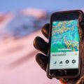
The backcountry just got a lot more high-tech. Avanet has been released and is available for download on your iPhone (Android version forthcoming). Avanet is brought to you by the same Park City-based geeks that built the Avatech SP1 – a probe pole that digitally reads and records snowpack data that cam be shared online. While the probe is an advanced tool for avalanche professionals, us recreation-types get to join in on the crowd-sourcing fun with Avanet.

So what exactly is Avanet? It’s an app that allows the user to map routes, view snowpack observations from peers in the field, and upload their own observations in real-time. You can include location, photos, videos, type of observations, maps and field notes. I downloaded the app to my iPhone this morning and found the interface to be intuitive and easy to use. I’m very much looking forward to testing it out on my first backcountry ski tour of the season.
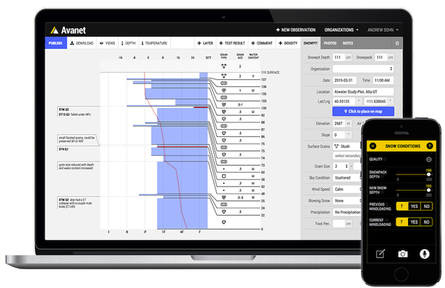
According to a press release, the new Avanet mobile app also includes a route-tracking feature that allows users to monitor key statistics from their tours. Users can select over 20 different topo and aerial maps all on a single platform fully integrated with observation information. All mobile data is synched with the Avanet web platform, where users can plan and share routes and dynamically visualize terrain on Avanet’s new GIS platform.
“At Avatech our mission is to build a safer mountain community. The Avanet platform helps everyone communicate and share information in the mountains more easily than ever before. Our global mountain community can now share real-time, geo-tagged observations of snow conditions, weather, wind, avalanches and more,” says Brint Markle, co-founder and CEO of Avatech. “Now all mountain travelers – skiers, snowboarders, snowmobilers, snowshoers, mountaineers and the professional snow community – can benefit from the information shared on the Avanet mountain safety platform. And when we share information, it’s a win-win for everyone.”
Avanet is available in three versions: Avanet, Avanet Tour and Avanet Pro. Avanet is a complimentary version for recreational mountain travelers and includes such features as basic topographical and aerial maps, tour tracking and the ability to submit and view public observations. Avanet Tour ($5 per month) includes additional features like terrain visualization and route planning tools. Avanet Pro ($10 per month) is the most feature-rich platform designed for professional guides and snow safety professionals and includes such additional tools advanced route planning, professional-grade observation sharing, pro data access and more.
“The more knowledge you have the better,” says professional skier and mountaineer Chris Davenport. “Crowdsourced, real-time information about what’s happening in the mountains, in the backcountry, benefits professional forecast centers and backcountry users everywhere. I use Avanet in the field and trip planning, and it’s been a game-changer in how I prepare to go into the mountains.”
You can download the Avanet mobile app to your iPhone from the Apple app store, or go to Avatech’s website for more information.