Capitol Reef National Park has long been praised by the outdoor crowd as a hidden treasure in Utah. Incredible scenery, no entrance fees, and often scant crowds are just a few of the reasons for this. However, even in the most hidden of places, warm weather and jaw-dropping natural splendor will eventually lure plenty of visitors. If it is solitude you seek, Upper Muley Twist Canyon is the place for you.

Why are there less crowds at Upper Muley Twist Canyon? For starters, it’s way off the beaten paths of UT24 and the visitor center area. Thirty-eight miles from the start of the Notom-Bullfrog Road, to be exact. It’s quite an investment in time and vehicular distress to get there, and when you do arrive, a moderately strenuous nine-mile hike is what awaits. For some folks, the long drive, strain on your vehicle, and tough hiking just don’t seem worth it. But for those adventurers amongst you, I assure you that this trek pays off at nearly every turn.

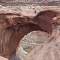
Let’s fast forward to the goods: Upper Muley Twist! The canyon cuts lengthwise along the Waterpocket Fold, and millions of years’ worth of erosion has created a rock wonderland full of interesting formations and numerous arches. From the trailhead, walk north for the first 1.7 mile leg of the journey. At the trail junction, look up to the west wall of the canyon to spot Saddle Arch. Here, hikers will have to choose which direction to tackle the rest of the way. Hiking clockwise will put you in the canyon route first; counter-clockwise means you tackle the Rim Route, and get most of the elevation gain out of the way ASAP. My partner and I chose the Rim Route, and the climb was short but intense!

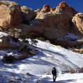
Cairns are a huge part of this hike, marking the way for a majority of Upper Muley. These stacks of rock mark the switchbacks that lead to the top of the Waterpocket Fold, and once on top, the views are outstanding. Looking west, you can clearly mark the varied geology of Strike Valley, Tarantula Mesa, and the peaks of the Henry Mountains. The route continues north along the spine of the Fold, and the transition of color is abrupt and beautiful. Layers of red and white that cut on sharp angles through the canyon below are highlighted by the occasional flashes of vibrant green trees, and of course, that unique blue hue that belongs to the desert sky.
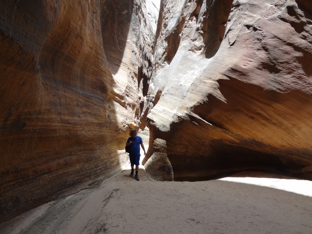
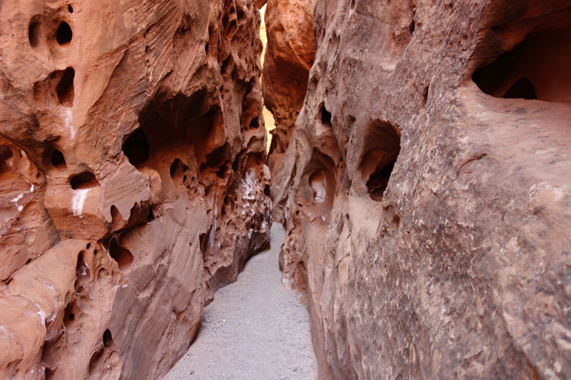
After 2.7 miles of slickrock hiking on the rim, it is time to descend into the lower reaches of Upper Muley Twist Canyon. The way down has a couple tricky spots, but all are well marked and safe enough as long as you take your time. The trail now becomes classic wash hiking: sandy and slow. High walls of multicolored stone provide a nonstop display of cracks, pillars, arches and other oddities. A section of narrows is also waiting to be explored, and while short, they are indeed a true slot canyon. It’s dark and cool in this section; a welcome retreat from the hot southern Utah sun.

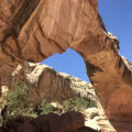
The trail eventually returns to the junction with the Rim Route, where travelers will backtrack the first 1.7 miles of the hike. The walk is nine miles total, with at least five arches along the way, as well as countless other spectacles indicative of this special country. From the depths of the wash to the top of the Waterpocket Fold, Upper Muley Twist Canyon truly delivers a textbook Colorado Plateau adventure!
Getting There: From the Capitol Reef Visitor Center, drive east for 9 miles on UT24, and then turn south on Notom-Bullfrog Road. The road heads due south, and the first 10 miles are paved. Once the pavement ends, the road becomes a mix of shallow sand and washboard that is passable for almost any vehicle. Drive a total of 33 miles on Notom-Bullfrog Road before turning west onto the Burr Trail Road. Continue up the famous Burr Trail Switchbacks, approximately 2 miles until reaching the signed junction for Upper Muley Twist Canyon.
Low clearance vehicles will need to park along this portion of the road. Parking here adds 5.8 miles to the hike (2.9 miles one-way distance to the trailhead). This is the reason that many folks hike this canyon as an overnight backpacking trip. If you have a high-clearance four-wheel drive vehicle, it is possible to continue up the road to a parking area at the trailhead. I did this drive in my stock Xterra, and had little difficulty (in fact, it was downright fun!).