
GPS devices are expensive, but smartphone apps are really cheap. Combine the two, and you’ve got ViewRanger, a smartphone GPS app that has all the features of a GPS unit right on your phone. But the obvious question is: does a smartphone GPS app really work as good as the real thing? I downloaded the iPhone version of ViewRanger and took it on several outdoor adventures to find out.
")
First off, ViewRanger says their app can do everything a standard GPS can do, like plan your trip, plot the route, navigate you to your destination, locate your location, record your tracks and analyze your trip’s time and distance. Plus, when you’re back home, you can share your adventure with friends by uploading everything online.
The company also claims that you can use ViewRanger almost anywhere in the world by using Open Source web maps. It also has the option of upgrading to topo maps for the U.S. What’s great about this is that you can use the app even if your phone loses the cell signal since the maps are all stored in the phone.

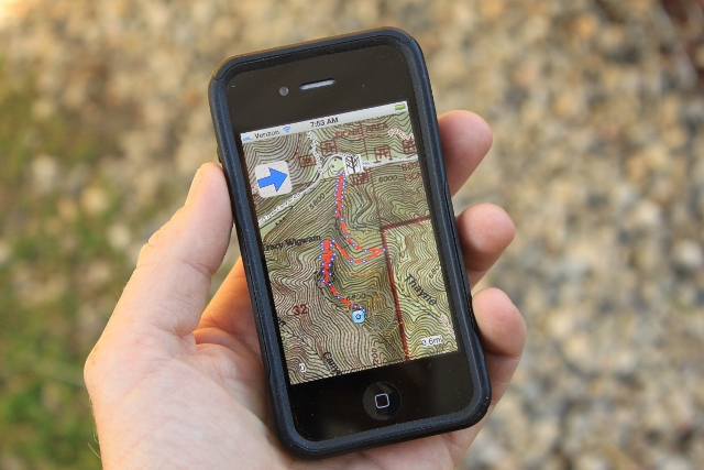
During my testing of the ViewRanger, I mostly used it to create GPS tracks of mountain bike rides in Utah. I had the app track me on Ann’s Trail in Corner Canyon, the Little Cottonwood Trail, on the Mueller Park Trail in Bountiful, and Thunder Mountain in Southern Utah. Every time I set the app to track my route, it did, spot on. I was then able to upload the track to the web where a downloadable GPX file could be put into Google Earth.
A great thing about ViewRanger is the online community at ViewRanger.com, where people share their routes, which you can download for your own adventures. To test one out, I downloaded a route for the Desolation Trail in Mill Creek Canyon. I set the app to follow the route, and it did, until near the end. At that point, just before the Salt Lake Overlook, the ViewRanger put my coordinate closer to neighboring Thaynes Canyon, and not at the overlook. However, when it did work, it was pretty cool. An arrow in the upper left corner of the screen shows you the right direction and indicates with green or red colors. Another arrow on the map shows you what direction you are facing relative to the route. While following the trail was obvious, it was a good place test the app’s ability to follow an uploaded route.

Personally, I’ve never found much use for using GPS devices to route find, but use them a lot to create tracks. For that purpose, the ViewRanger is perfect and never lost the signal even in areas where service was low or even gone. That being said, the app requires the smartphone’s GPS be turned on at all times, which seriously drains the battery, fast. On one three-hour mountain bike trip, I opened my pack to find my iPhone 4S totally dead because of the ViewRanger tracking me. As a result, I would not rely on ViewRanger on very long backpacking trips where you can’t recharge your device, or are relying on you phone in case of an emergency situation.
Overall, the ViewRanger GPS app is an impressive, easy to use and intuitive program for tracking and route-finding. It does just about everything an expensive GPS unit can do, at a fraction of the cost. So if you’re looking for an outdoor specific GPS but don’t want to drop upwards of $500 on it, but you do have a smartphone, then the ViewRanger GPS app is a no-brainer.
The ViewRanger GPS app runs on most phones that use either Apple, Android or Symbian operating systems. To download, search for it in your respective app stores, or go to www.viewranger.com

Great Post! Here’s part of a closely-related blog post I wrote recently called
“Your Smartphone as a Hiking GPS?”
By far the very best GPS app we’ve found for our Android phone (a Motorola Droid Razr Maxx) is a paid one called BackCountry Navigator Pro (“BCN”). It only costs $10 (one time charge) – which is far cheaper than buying a stand-alone GPS receiver. It’s also probably lighter and maybe even has a larger screen. By the way, you can try the full featured BCN for 30 days for free. As far as I know it only works (so far) with Android phones.
BackCountry Navigator doesn’t even need to be in range of cell towers so it continues working even in, well, the backcountry. It can use a wide variety of common topological maps from all over the world. You can even download and upload tracks from/to your computer. Also for a small added cost you can download specialized maps like Horse Trails or ATV trails for the USA.The app writer, Nathan Melor, does an excellent job of keeping his users well informed and is very responsive to user needs and desires. You can tell I really like this app, but I have no association with it other than being a very satisfied customer.
Come to visit at http://thenatureofhiking.com/smartphone-as-your-hiking-gps/.html#more-603
to read the rest…
Jack McCarron
TheNatureOfHiking.com