There are nineteen “13’ers” in Utah, and every one of these beasts can be found somewhere in the Uinta Mountain Range. One of the things that make Utah’s 13,000′ mountains unique is their distance from roads. Climbing these summits often means a multi-day backpacking trip, or at least a 15+ mile single day epic hike. At 13,165′, Tokewanna Peak ranks as #12 on the list, and it just so happens that it’s the closest 13’er to any road. Don’t let that fact fool you: Tokewanna is in a very remote portion of the High Uintas, and the trail system in these parts isn’t exactly well-maintained. Recently, some friends and I decided it was the perfect time to knock it off the list, and made the trek. It is a gorgeous area and one hell of a summit hike!
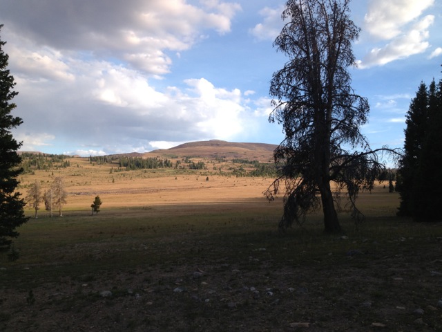
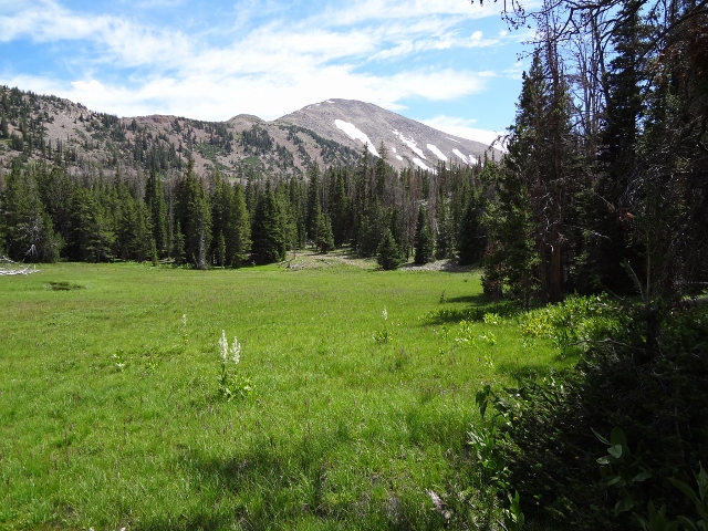
We hit the road around 10am on Friday morning. As usual, the picturesque drive up Mirror Lake Highway served to boost our excitement, and when we arrived at the West Fork Blacks Fork Trailhead, we were ready to roll. Our plan was to camp for two nights near Tokewanna’s Northwest Ridge route, with Day 2 as summit day. The trail is well marked here, complete with a register that will indicate just how many folks you won’t be seeing. There was not a single group headed to our destination! After a recent trip to Kings Peak was marred by the dreaded Boy Scouts of America, I was happy to know we’d have this place to ourselves. We headed east on the Smiths Fork-Black Fork Trail, and it redefines the term “stairmaster.” Seventeen switchbacks sent us up 1,200′ in roughly three miles. Quite the workout! When we arrived on top of the ridge area, we were surprised to see a cowboy camp set up just off of the trail. A huge, open meadow at 10,500′ is apparently the best place to graze sheep, and about 200 of the bleating bastards were waiting for us. Unfazed, we set off across the meadow to find Brush Creek, our planned home for the weekend.
The trail becomes sketchy at best at this point. Rock cairns do a decent job of pointing the way, but to be honest this was the faintest trail I have ever hiked in the Uintas. At points we simply navigated with map and compass to find our way. We hiked north along Brush Creek until it started flowing, and there we set up camp. We head clear skies and warm temps, and the three of us enjoyed a fine night by the fire.
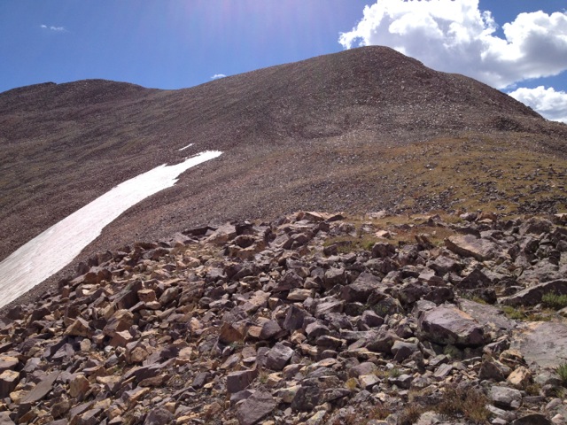
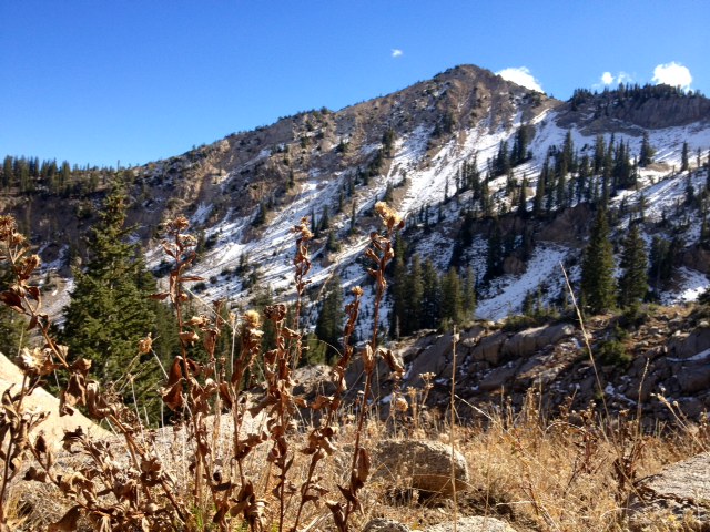
The next morning we set out for our objective. Tokewanna Peak could be seen some five miles in the distance, towering over the Northwest Ridge route. We had a lot of ground to cover, and about 2,600′ of vert between us and the summit. Only my buddy, Randy, and I would be making the hike (our friend Jeff had to bail, and we parted ways near the cowboy camp). The two us walked up through the field, taking in the amazing scenery. Despite the sheep cacophony, we still felt very alone. The terrain changed from soft grass and lodgepole pine to the High Uintas tundra. Only the most rugged flowers and shrubs live in this area, and their tough beauty always impresses me. Soon, the tundra was peppered with rocks, as the transition to true mountain began.
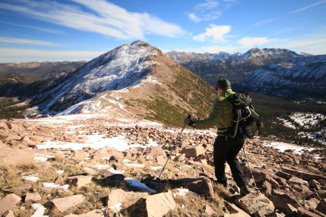
The only downside to the Northwest Ridge route is near the halfway point. An 11,800′ sub-peak is climbed, only to break your heart by dropping some 300′ on the south side. Once you descend, it’s right back up again; over 1,600′ in two miles. Brutal! So brutal that my partner waived the white flag. He said it would be foolish for him to continue on, and I admired his honesty. It must have been hard to back off with the peak now within our grasp. Randy said he would wait for me at our current location, and I headed on by myself. He shouted that he saw another hiker on the ridge, but I figured he was just trying to boost my morale.

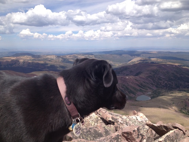
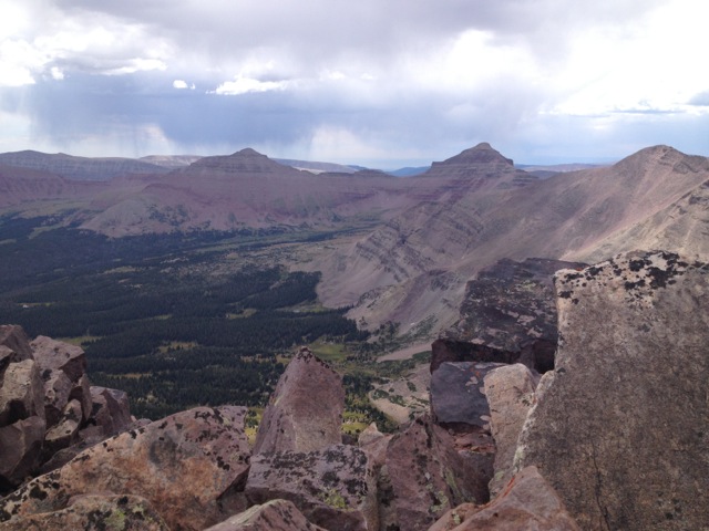
Imagine my surprise when about an hour later I made the summit and found our friend Dave waiting at the top with his dog! We were supposed to link up the night before, but couldn’t find him by the time darkness fell. He decided to head to the top of Tokewanna, the only place he was sure he would see us. We took a nice, long break at the peak, soaking up the views from on high. And what a view it is: from the top of Tokewanna, Kings, South Kings, Mount Powell, Lovenia, and several other Utah 13’ers are easily identifiable. Sitting amongst these giants was awe-inspiring to say the least; this hike is worth making just for the views.
Dave, Luna the dog and I packed up and headed to meet Randy. Cloud cover rolled in just as he came into view, and a light hail started to fall on us. Seems our timing couldn’t have been better. Minutes later we heard the ominous sound of thunder in the distance, and decided to high-tail it back to camp. My quads ached as I sat by the fire that night, but the staggering beauty and satisfaction of ticking off a major summit made all the pain worth it. There’s still nothing better to me than getting really high with some great friends, and Tokewanna Peak is a worthy place to do it. If you want solitude and splendor, I don’t know if there’s another hike in the Uintas that can deliver like Tokewanna.
Getting There: From the town of Kamas, follow Mirror Lake Highway north for 49 miles. Turn right on SR 058, also marked as “North Slope Road.” Drive east for 16 miles to a four way intersection with West Fork Blacks Fork Road. Turn south and follow the rough dirt road for approximately 4 miles, where it will intersect with the West Fork Blacks Fork River. You can ford the river with your vehicle and drive the additional mile south to the trailhead, but it is advisable to park here and just hoof it. The roads are drivable for most vehicles, but a high clearance vehicle would be more ideal for the rough 4 mile section at the end.
Maps: USGS Top maps for Lyman Lake, Red Knob, and Mount Lovenia; Trails Illustrated Map #711: High Uintas Wilderness.
Gear Needed: A good pair of hiking boots and a water filter (thanks to the sheep in the area) are necessary for the trek.